
Table of Contents
- Exploring Avakas Gorge: Cyprus’ Natural Limestone Wonder
- Getting There by Car: The Route from Paphos
- Parking Options for the Avakas Gorge Hike
- Essential Hike Statistics and Difficulty Rating
- The Hiking Route: From the Trailhead to the Narrow Canyon
- Safety First: Flash Floods and Seasonal Hazards
- Best Time to Visit for Ideal Weather and Light
- Essential Kit List for a Successful Trek
- Extending the Adventure: Lara Bay and Beyond
- Frequently Asked Questions about Avakas Gorge
Avakas Gorge sits at the western edge of the Akamas Peninsula, where towering limestone walls press together until they’re barely a metre apart. It’s one of Cyprus’ most dramatic natural formations, and for years it drew hikers from across the island. But conditions in 2026 have changed significantly, and anyone planning a visit needs current information before setting out. Here’s everything you need to know about the gorge, the road that leads to it, where to park, and what to expect right now.
⚠️ Important: Trail Closure in 2026
The Avakas Gorge Nature Trail is officially closed to the public as of October 2026 due to safety hazards including increased water flow and rockfall risk. A mass rescue operation on 25 March 2026 saw 31 hikers extracted after being trapped by rising water inside the canyon. Do not attempt to enter the gorge while the closure remains in effect. Check with the Paphos District Office or the Department of Forests for the latest status before planning your trip.
Exploring Avakas Gorge: Cyprus’ Natural Limestone Wonder
The gorge itself is a product of millions of years of erosion. The Avgas River has carved a narrow passage through soft limestone, creating vertical walls that rise 30 metres or more in places. At its tightest point, the canyon narrows to roughly a metre across, forcing hikers to pick their way over boulders wedged between the rock faces.
The official nature trail is a linear 1.2 km path (one way), placing it within a designated Natura 2000 zone. That protected status means the surrounding ecosystem is considered ecologically significant at a European level. You’ll find rare endemic plants clinging to the rock faces and, if you’re lucky, glimpses of wildlife that thrives in this relatively undisturbed corridor.
The gorge’s location on the Akamas Peninsula puts it among a handful of genuinely wild landscapes left in southern Cyprus. Unlike the resort-lined coasts further east, this part of the island retains a raw, unmanicured character. That’s part of its appeal, but it’s also the reason access can be tricky and conditions unpredictable.
Getting There by Car: The Route from Paphos
The drive from Paphos town to the Avakas Gorge trailhead covers roughly 25 km and takes about 45 minutes in normal conditions. The first portion is straightforward: head north on the main road toward Peyia, then continue through the village toward Agios Georgios. Signs for the gorge appear intermittently, though they’re not always reliable, so having a GPS or offline map loaded is sensible.
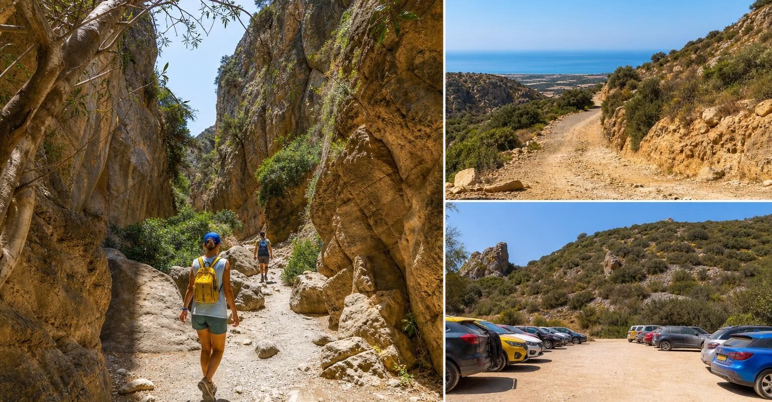
From Agios Georgios, the paved road gives way to a dirt track that runs along the coast. This is where the drive changes character entirely. The final stretch to the parking area is approximately 5 km of unpaved road, and its condition varies dramatically depending on the season and recent rainfall.
| Route Segment | Distance | Surface | Estimated Time |
|---|---|---|---|
| Paphos to Peyia | 12 km | Paved | 15 min |
| Peyia to Agios Georgios | 8 km | Paved | 12 min |
| Agios Georgios to trailhead | 5 km | Unpaved/dirt | 15-20 min |
Navigating the Dirt Track and Road Conditions
The unpaved section is the part that catches people out. After dry spells, the track is rutted but passable at low speed. After rain, sections can become muddy, waterlogged, or washed out entirely. Deep potholes appear without warning, and loose rocks can scrape the underside of a low-clearance vehicle.
A 4×4 or SUV handles this stretch comfortably. A standard saloon car can technically make it in dry conditions, but you’ll be crawling along at walking pace and risking damage to the suspension, tyres, and exhaust.
⚠️ Warning: Rental Car Restrictions
Most rental agreements in Cyprus explicitly exclude driving on unpaved roads. Taking a standard rental car onto this dirt track carries a minimum violation fee of €450, while SUVs or 4x4s incur a €600 fine if driven off-road in breach of the contract. If you damage the vehicle on the track, your insurance almost certainly won’t cover it. Check your rental terms carefully before committing to this route.
Construction on Phase A of a revised Akamas road network covering 9.9 km – including the Toxeftra to Avakas stretch – is scheduled to begin in Q4 2026, with the broader infrastructure project aiming for completion by the end of 2027. This should eventually improve access, but during 2026 expect possible construction activity and temporary diversions.
Parking Options for the Avakas Gorge Hike
The main parking area sits at the end of the dirt track, a flat clearing with space for around 20 to 30 vehicles. There are no attendants, no barriers, and no fees. It’s simply an open patch of ground beside the riverbed.
Arrive before 10:00 in peak season (April to June, September to October) if you want a guaranteed spot. By midday on busy days, cars spill along the roadside, narrowing the track and making it difficult for vehicles to pass. There are no toilet facilities at the car park, and shade is minimal, so don’t leave anything perishable in the vehicle.
A second informal area exists a few hundred metres back along the track. It’s less convenient but perfectly usable if the main clearing is full. Either way, don’t leave valuables visible in your car. Petty theft from parked vehicles at remote trailheads isn’t common in Cyprus, but it does happen.
Essential Hike Statistics and Difficulty Rating
The official trail covers 1.2 km one way, making the full return walk roughly 2.4 km. That sounds short, but the terrain makes it slower than you’d expect.
| Detail | Information |
|---|---|
| Trail length | 1.2 km one way (2.4 km return) |
| Typical duration | 1.5 to 2.5 hours return |
| Elevation gain | Minimal (mostly flat riverbed) |
| Difficulty | Moderate |
| Surface | River boulders, loose rock, occasional water |
| Marked trail | Partially – cairns and faded paint marks |
The “moderate” rating reflects the terrain rather than the distance. You’re scrambling over large boulders for much of the route, and some sections require basic hand-and-foot climbing to get past obstacles. Wet rocks are slippery, and ankle-twisting gaps between boulders are everywhere. This isn’t a paved nature walk.
Children over about eight can manage it with supervision, but it’s not suitable for pushchairs, wheelchairs, or anyone with significant mobility issues. Dogs technically aren’t prohibited, but the boulder scrambling makes it impractical for most pets.
The Hiking Route: From the Trailhead to the Narrow Canyon
From the parking area, a flat path follows the dry riverbed for the first few hundred metres. Fig trees and oleander line the banks, and the walking here is easy. Gradually, the canyon walls begin to rise on either side, and the path narrows.
Around the halfway point, you start encountering the large boulders that define the hike. The route picks its way between and over them, with no single “correct” path. You’ll see cairns (small rock piles) left by previous hikers, and faded paint marks on some boulders, but route-finding requires a bit of common sense.
The final section is the most spectacular. The walls close in dramatically, light filters down in narrow shafts, and the scale of the rock formations becomes genuinely impressive. This is where most people take their photos and where the gorge earns its reputation. The official trail ends where the canyon becomes impassable, and you retrace your steps back to the car park.
Flora and Fauna of the Akamas Peninsula
The gorge and surrounding Akamas Peninsula support a surprising range of species. The Natura 2000 designation exists partly because of rare plants like the endemic Cyprus tulip (Tulipa cypria), which blooms in March and April on the plateau above the gorge.
Within the canyon itself, ferns, mosses, and shade-loving plants cling to the damp rock faces. Fruit bats roost in crevices, and you might spot the occasional Montpellier snake basking on warm rocks (non-venomous, but best left alone). Overhead, Bonelli’s eagles and griffon vultures patrol the thermals above the Akamas ridgeline.
The riverbed habitat supports freshwater crabs and amphibians during wetter months. Spring is the best time for wildflowers on the approach path, with cyclamen and anemones carpeting the ground beneath the carob and olive trees.
Safety First: Flash Floods and Seasonal Hazards
Flash flooding is the single most serious risk in Avakas Gorge. The canyon acts as a natural funnel for rainwater, and water levels can rise with terrifying speed. Rain falling on the hills kilometres away can send a wall of water through the gorge with little warning at ground level.
The rescue of 31 hikers in March 2026 is a stark illustration of this danger. Those hikers entered in apparently calm conditions and found themselves trapped when water rose rapidly. Emergency services required hours to extract everyone.
🔴 Key Safety Rules
- Never enter the gorge if rain is forecast anywhere in the Akamas region, even if skies look clear overhead.
- Check the weather for the entire western Paphos district, not just your immediate location.
- If water in the riverbed begins rising while you’re inside, move to the highest ground you can reach immediately.
- Tell someone your plans and expected return time.
- Carry a fully charged phone, but be aware that mobile signal is weak to non-existent inside the canyon.
Rockfall is the second hazard. The limestone walls are naturally unstable, and chunks of rock detach without warning. Wearing a helmet isn’t standard practice among hikers here, but it’s not a bad idea. Stay away from overhanging sections where possible, and don’t linger directly beneath the narrowest parts of the canyon.
Summer heat is the third concern. Temperatures in western Cyprus regularly exceed 38°C between June and August. The gorge itself offers shade, but the approach walk and the car park are fully exposed. Heatstroke is a real risk for unprepared hikers.
Best Time to Visit for Ideal Weather and Light
The sweet spot falls between mid-March and late May, and again from mid-September to early November. During these windows, daytime temperatures sit between 20°C and 28°C, rainfall is less frequent, and the light inside the canyon is at its most photogenic.
Spring has the edge for wildflowers and greener scenery. Autumn offers warmer sea temperatures if you’re combining the hike with a swim at nearby beaches. Both seasons avoid the crushing summer heat that makes midday exertion genuinely dangerous.
Winter (December to February) brings the highest flood risk. Rainfall in the Akamas region peaks during these months, and the riverbed often carries standing water. Even on dry days, saturated ground upstream can release water into the gorge unexpectedly.
💡 Pro Tip: Early morning visits (arriving by 08:00) give you the best light for photography, cooler temperatures, and a near-empty trail. The gorge faces roughly east-west, so morning sun penetrates the narrow sections beautifully.
Essential Kit List for a Successful Trek
You don’t need technical climbing gear, but the right preparation makes a significant difference to comfort and safety.
- Sturdy footwear with ankle support and good grip (trail shoes or lightweight hiking boots; avoid sandals and flip-flops)
- At least 1.5 litres of water per person (there’s no drinking water on the trail)
- Sun protection: hat, sunscreen, and sunglasses for the exposed approach
- A light layer or windbreaker (the canyon interior can feel cool, especially in spring)
- Snacks or energy bars
- Fully charged mobile phone in a waterproof pouch
- Small first aid kit with blister plasters and antiseptic wipes
- A head torch if you’re starting very early or running late
Leave cotton clothing at the hotel. If you get wet crossing pools in the riverbed, cotton stays damp and heavy. Synthetic or merino layers dry much faster and won’t leave you chilled in the shaded canyon.
Extending the Adventure: Lara Bay and Beyond
Lara Bay sits roughly 8 km north of the gorge along the same dirt track network. It’s one of the last significant nesting sites for green and loggerhead turtles in the Mediterranean, and the beach itself is a protected conservation area.
The drive from the gorge car park to Lara Bay takes about 20 minutes on unpaved roads. The same rental car restrictions apply here, so factor that into your planning. If you’ve rented a 4×4 specifically for this area, combining both sites in a single morning makes excellent use of the vehicle.
Beyond Lara Bay, the Akamas Peninsula offers further hiking on the Aphrodite and Adonis trails near the Baths of Aphrodite, both of which start from paved roads and don’t require off-road driving. These make good alternatives if the gorge trail remains closed during your visit.
Combining the Gorge with a Visit to the Turtle Beach
A practical itinerary for a full morning: arrive at the gorge car park by 07:30, complete the hike by 10:00, then drive north to Lara Bay for a couple of hours on the beach before the midday heat peaks. Pack a cool box with lunch and plenty of water, because there are no shops or cafés at either location.
Lara Bay has no sunbeds, umbrellas, or facilities of any kind. That’s deliberate: the beach is managed for turtle conservation, not tourism. Between June and August, you’ll see protective cages over nest sites. Stay well clear of these, and avoid leaving any litter. Nesting season runs roughly from May to October.
If you’re renting a car from Paphos specifically to cover this part of the coast, booking a 4×4 for the day makes the logistics much simpler and keeps you on the right side of your rental agreement. CyprusCarRental can help you find suitable vehicles with the right insurance cover for unpaved roads.
Frequently Asked Questions about Avakas Gorge
Is Avakas Gorge open in 2026?
As of October 2026, the trail is officially closed due to safety hazards including rockfall and flood risk. The closure followed a major rescue incident in March 2026. Check with local authorities for the latest status before travelling.
Can I drive a normal rental car to the gorge?
Technically, a standard car can reach the parking area in dry conditions, but most rental contracts prohibit unpaved road driving. Breach of this clause can result in fines starting at €450 and void your insurance cover. A 4×4 is the safer and more practical choice.
How long does the hike take?
The 2.4 km return walk typically takes between 1.5 and 2.5 hours, depending on your pace and how long you spend in the narrow canyon section. The terrain is uneven, so allow more time than the distance suggests.
Is the gorge suitable for children?
Older children (roughly eight and above) who are comfortable scrambling over rocks can enjoy the hike with close supervision. It’s not suitable for very young children, and there’s no way to bring a pushchair.
What happens if it rains while I’m inside?
Leave immediately. Water levels can rise within minutes from rainfall upstream that you can’t see. The March 2026 rescue involved 31 people who were caught by rapidly rising water. Never enter if rain is forecast anywhere in the region.
The Avakas Gorge remains one of the most striking natural features on the island, even if 2026 isn’t the year to walk through it. The closure exists for good reason, and the road improvement works should eventually make the entire area more accessible and safer. For now, you can still drive out to enjoy the Akamas coastline, visit Lara Bay, and walk the approach path to appreciate the gorge entrance from a safe distance. Keep an eye on official announcements through 2027, and plan your gorge hike for when the trail reopens with proper safety measures in place.